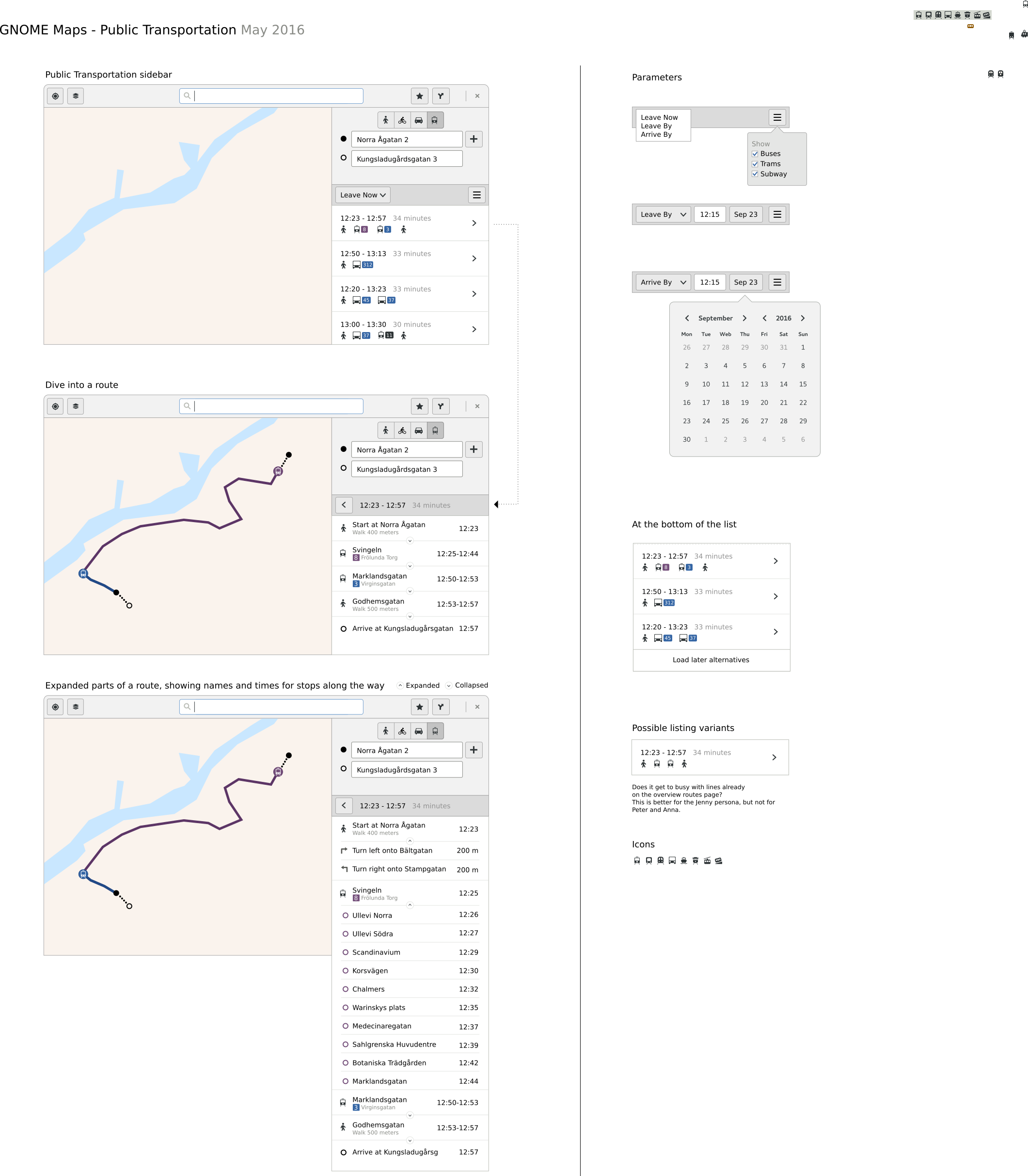
Design for public transportation in Maps
See also
Previous art
Google Maps previousart-google.jpg
Apple iOS Maps https://www.youtube.com/watch?v=czue6kKmjeM
Apple OSX Maps https://www.youtube.com/watch?v=z_3wVn1XI2k
Bing Maps previousart-bing.png
Västtrafik previousart-vasttrafik.png
Reserobot previousart-resrobot.png
Google Maps Mobile previousart-google-maps-android-overview.png previousart-google-maps-android-expanded1.png previousart-google-maps-android-expanded2.png
Google Maps Mobile showing an itinerary with gondola transit previousart-google-maps-gondola.png
Stockholm Länstrafik previousart-sl.png previousart-sl-expanded.png
Background interviews
https://wiki.gnome.org/Design/Apps/Maps/PublicTransportation/Interviews
Stories
Jenny lives in Upper West side, New York, US. She's 27 years old and moved to New York a couple of months ago from Flint, Michigan to try and make it as a musician. She currently works in a clothing shop in Brooklyn. She's still trying to learn how to find her way around the city. She uses her computer for a couple of hours every night, but only just now started using GNOME Maps. Jenny needs to be at work before 09:00. She gets carsick very easily and therefore wants to avoid to go by bus if possible.
Peter just moved to a new apartment around Möllevången in Malmö, Sweden to live together with his girlfriend in the apartment they just bought. He used to live in another part of Malmö before, so he finds his way around Malmö with ease. He works as a high school teacher. His own computer is currently broken, so he has an account on his girlfriends computer running GNOME. He's not super-familiar with the OS and the apps, but finds his way around. It's Saturday and he's busy repainting the kitchen. His paintbrush just broke and he needs to get a new one. He know they have good paintbrushes at a good price at this store in a shopping center a bit outside of the center of Malmö. He needs to get there as soon as possible and checks when the next bus goes there.
Anna lives in Rio and is 22 years old. About a year ago she bought a computer with GNOME preinstalled. She works as a graphics designer for an ad agency. She has a meeting at a customer and promised her friend that she would stop by afterwards for coffee. Her friend asks when she'll arrive. Anna's plan is to go to her friends right after the meeting is over at around 17:00. To give her friend an estimate, Anna needs to figure out when she'll arrive at her friends place, assuming she leaves the office at around 17:10.
Robert is 46 years old and lives on the countryside outside Onsala with his wife Lisa and three kids. He works as an accountant. He's been using GNOME for over 10 years and he's been using Maps in the past, but not the public transportation option. He's not super-good at finding his way around using a map and need clear directions. He owns a car. He would like to go to a bar together with some friends in Gothenburg, so he would like to leave the car at home and go there by public transportation. He agreed to meet up with some friends on Vasagatan in Gothenburg at 18.00. He'll need to take several different means of transportation to get there, and he'll need to know when the last bus goes back home.
Workflows
Jenny opens up her laptop and launches GNOME Maps. She does a search for Brooklyn and pulls up the routing for it. She makes sure the public transportation option is selected. She sets the arrival time to 09:00. She filters out the option for buses and gets a number of results back. She selects an option that arrives at 09:54 and gets details about that route. At the appropriate time she heads to the subway. She takes the subway to Brooklyn and arrives at the appropriate time.
Peter cleans the paint off his hands and sits down at his laptop. He opens up GNOME Maps and searches for the address of the shopping center. He selects the public transportation option and gets a couple of options that leaves from his place soon. He gets a couple of different options. He chooses to go with a bus that leaves in 5 minutes from the stop closest to his place. He'll have to switch buses in the city center, but he thinks that's fine, because that allows him to get to the shopping center faster.
Anna launches GNOME Maps. Inputs the location of her the customers office and the address of her friends place. She inputs the time 17:10 and gets a number of suggestions of transports. She notes the number of a good bus and it's arrival time in GNOME Calendar. She then sends the arrival time to her friend over chat.
Robert sits down at his computer. He hits the super key and searches for Gothenburg in the shell overview. GNOME Maps launches and he'll get Gothenburg selected on the map. He selects the routing option and gets it routing from his current location. He selects the public transportation option and selects the end destination and an arrival time of 18:00. He prints the entire route. Once that's done, he reverses the route and selects a time that he guesses is late enough. He notes that he'll need to leave the bar at 22:05 at latest. He prints this route as well. He takes a note of the name of the stop before his last stop so that he can press the bus stop button in time.
Wireframes

